For a thousand years, the Micronesian island of Pohnpei was ruled by a clan of aristocrats called the Saudeleur. They constructed artificial islands on top of existing coral reefs at Nan Madol and raised buildings and temples on these new platforms. There they ruled, about a thousand or so people out of a total Pohnpei population of 25000. Then, about 500 years ago, the Saudeleur were overthrown by a foreign interloper who established a new system, a sort of confederation of five different clans. Nan Madol was left to erosion and the encroaching jungle.
![Outside a retaining wall at Nan Madol [S.W.Batzer, flickr.com]](https://shrineodreams.wordpress.com/wp-content/uploads/2013/06/nan_batzer.jpg)
Outside a retaining wall at Nan Madol [S.W.Batzer, flickr.com]
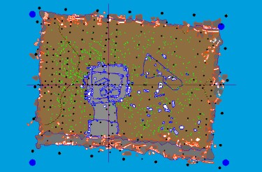
![Map of the Nan Madol complex. [Wikimedia Commons]](https://shrineodreams.wordpress.com/wp-content/uploads/2013/06/nan_map.png)
Map of the Nan Madol complex. [Wikimedia Commons]
Perhaps two thousand years ago people began adding fill to the tops of the coral reefs around Pohnpei but it was the Saudeleur who introduced construction using giant columns of basalt brought to the reef from the inner island. Columnar basalt is pushed up by the same volcanic forces that created the island of Pohnpei. It cools slowly and fractures in a polygonal pattern. Hexagonal sided columns are common and, on Pohnpei, quite a bit of pentagonal forms as well. These foundation pieces may weigh a few tons up to fifty tons. It is unknown how such massive stones were moved to their present site.
![Basalt column walls, Nan Mador. [S.W.Batzer, flickr.com]](https://shrineodreams.wordpress.com/wp-content/uploads/2013/06/nan_batzer2.jpg)
Basalt column walls, Nan Mador. [S.W.Batzer, flickr.com]
These basalt columns were laid down as retaining walls for fill until an island platform was formed. Then, domestic buildings, temples, and other kinds of structures were erected on the islands. Between the islands, seawater ran in canals. Ninety-two of these islands were built. The largest is about a hundred meters by fifty meters and was the site of a mortuary where the bodies of dead Saudeleur royalty were set out before being taken elsewhere for burial.
![Mortuary site where royal corpses were laid out. [Christopher Pala, Smithsonian Magazine ]](https://shrineodreams.wordpress.com/wp-content/uploads/2013/06/nan_smiths.jpg)
Mortuary site where royal corpses were laid out. [Christopher Pala, Smithsonian Magazine ]
There is speculation that Nan Madol served as both a royal seat and a preserve where aristocratic competitors for power could be kept under control. Religious sites on one island have been excavated. Here, priests sacrificed sea turtles and fed their meat to sacred eels — one legend has it that the canals were originally constructed to allow the passage of eels.
After the Saudeleur were overthrown a new system of government arose on Pohnpei where five divisions of the island, now termed municipalities, were each ruled by a particular clan. There was no more need for a single royal place, so Nan Madol was abandoned. The islanders generally regard the ruins as a place of bad luck and stay away.
Archaeological diagram showing how one island was constructed: basalt columns outlined in red, structures erected on the island in blue, finds of pottery in light green. [W.S.Ayres, U. of Oregon
After World War II, the United States controlled Micronesia and, in the 1980s, declared Nan Madol a National Park. But, in 1985, Pohnpei achieved independence and, since that time, the ruins have had no particular legal protection. There is a move to have Nan Madol declared a UN Heritage Site but before that can happen, an agreement has to be reached between the chief of the municipality that includes Nan Madol and the leadership of Pohnpei as a whole. No one seems terribly interested in expediting this situation.
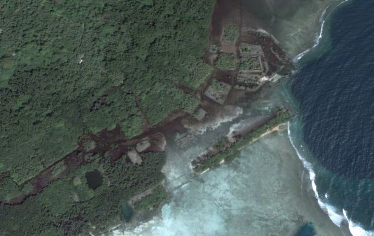
Ruins of Nan Madol, Google Earth
Nan Madol gets a few hundred tourists a year. They walk along the basalt retaining walls and look down into the canals that still have water at the colorful tropical fish. The islands are mostly overgrown with mangrove trees and the site as a whole is being claimed by jungle on one side and eroded by the sea on the other.
More:
An overall look at Nan Madol with links.
Info from William Ayres, U. of Oregon archeologist.
Nan Madol page from the International Archeological Research Institute, Inc.
Smithsonian article on a visit to Nan Madol.
Metropolitan Museum of Art page.
Archaeology Magazine, “Land of Flying Stones”

I am very interested in this…i beleive that if the United State is still in controlled of ponape this place will be in better shape and that more people will pay attention to these mystery sites.ofcourse if no one does than our future generations will never understand the deep mysteries that occured on these places.and if more studies were to be conducted you never know what you can find.
Does the”Saudeleur” word have any connection to the word “Saudi?”
No.
Micronesia is so fantastic! Especially Nan Madol is such an exotic and exciting place. I went there by foot, not all the way from Germany of course, but through the jungle and the waters of Temwen Island. Many sea snakes and enormous stingrays bothered me on my stroll to Nan Dowas. But nevertheless I will never forget this hazardous day.
[…] The small islands of Micronesia were far enough apart so that invasion from another island was not an everyday occurrence — yet it did happen. In the 16th Century, Pohnpei was invaded by a force from the island of Kosrae. These invaders overthrew the Saudeleurs, w… […]